Middletown (George School) supportive of the project, Newtown and Newtown Borough all have already approved a resolution of support for the Newtown Rail Trail.
The Newtown Rail Trail will be a County Park.
Federal and State Grants will pay for this trail.
(Northampton Township to Newtown) By the time funding is secured and all the details of design and construction ironed out, estimates of actual work might not start until 2025, with another year to completion.
Hours of the Park are Dawn to Dusk.
The County will handle major repairs.
The County will provide split rail fencing and landscaping on a case-by-case basis. Click Here to see plans.
Rest Rooms will be available at the Churchville Nature Center.
Parking will be available at the Churchville Train Station and the Churchville Nature Center.
Poster from the Northampton Township Information Meeting:
Trail is supported by adopted Northampton Township plans.
R-20-6, Resolution Supporting the Concept of Constructing a Walking/Biking Trail on the Former SEPTA Rail Line Right-of-Way. (Adam Selisker, the board chairman, added language to the resolution assigning the township manager, police chief and engineer the duty of making sure privacy and safety concerns remain a priority throughout the process).
Township’s Park & Recreation Plan (adopted 2014, pg. 8-5) & Open Space Plan (2010, pg. 17)
Public support for Newtown Rail Trail is documented in Park/Rec. Plan (pg. C-2)
Costs to Township should not be significant.
Maintenance cost is $10,000 a year maximum. About $0.71 per household.
Current Township Park & Rec. maintenance budget is about $436,000 (2016).
Interviews with Doylestown police (with many miles of trails): costs will not be significant.
Northampton Township police chief: No additional police personal will be needed.
Northampton Township Manager: police costs for a 4.5 mile linear park would be insignificant.
Property values for homes near trails are higher than for homes farther away.
Statistical research in Delaware, and in suburban Indianapolis, Green Bay, Cincinnati, and Boston all conclude: homes close to trails have values 4–9% higher than similar homes farther from trail.
Homes close to the trail can expect a $20,000 to $50,000 increase in value.
Liability is not an issue.
County and Township are both protected by Pennsylvania Recreational Use of Land & Water Act.
Interviews with insurance agents conclude: Individual homeowner’s AND Homeowners Association’s liability insurance will not increase.
Crime does not increase along trails.
Nationwide study (of 372 trails with over 7,000 miles of trails in 38 states) concluded that major and minor crime rates on trails are very low and had not increased due to trails.
When study is compared to average crime rates in Northampton: rates are lower on trails.
Interviews with police in Doylestown Township (with many miles of trails) and rangers who patrol D&L canal towpath conclude: no increase or issues related to crime in their areas.
“Stranger Danger” is fear-mongering.
Road Crossing Safety is part of County design.
State and federal design guidelines require safe road crossings. All state roads (Bristol Road, Bustleton Pike, Holland Road, and Buck Road) will require a state permit, PADOT approval.
Some examples of trail/road crossings can be found at Terwood Drive and Welsh Road.
Animal habitat will not be ruined.
The old rail line runs through a suburban, developed area. Animals are habituated to this.
Rail right-of-way is at least 60 feet wide, trail will only take up 12 feet. Animals will not be impacted by this.
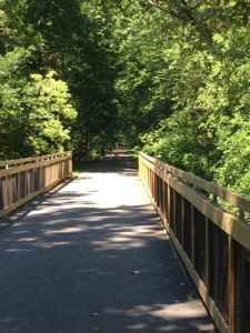
Wildlife use trails also. This turtle seems to enjoy walking the trail in New Hope.
Newtown Rail Trail will be a “linear park” and will benefit for residents in many ways:
Connects neighborhoods, shopping (Village Shires), parks (Churchville Nature Center and Tamanend).
Recreation and healthy living.
A safe place for children and families to cycle.
A safe way for students to get to school and a safe place for local teams to train.
Beautiful views of the Churchville Reservoir and the Neshaminy Creek.
Connects to a regional trail network (“The Circuit”), expanding access to many places.
Provides means to travel around township without a car.
Provides a connection to “The Neshaminy Greenway”
Trail will benefit businesses along/near it: studies show that trail users spend money.
The Newtown Rail Trail and the Neshaminy Greenway go right past the Village Shires Shopping Center.
What is a Bike Sharrow?
Sharrows are pavement markings that improve cycling safety on streets that are too narrow for traditional bike lanes. These markings indicate to drivers that the road is a preferred bicycle route, and that they should be prepared to share the road with cyclists. The placement of the sharrow shows cyclists where they can ride to avoid traveling in the door zone of parked cars.